Quick Answer
- Similar to Plus Codes in Google Maps, DIGIPIN assigns a unique alphanumeric code to every address or point on the map, offering precise geolocation without relying on traditional street names or landmarks.
- DIGIPIN uses a unique 10-digit alphanumeric code for each location, which makes it easy to identify and locate a place on the map.
- In this guide, let’s see how to convert a DIGIPIN into a Google Maps location and find any place with pinpoint accuracy.
The Government of India has launched a new system called the Digital Postal Index Number, or DIGIPIN, to revolutionize how we share and search for locations. Similar to Plus Codes in Google Maps, DIGIPIN assigns a unique alphanumeric code to every address or point on the map, offering precise geolocation without relying on traditional street names or landmarks.
DIGIPIN is also backed by the Department of India Post. It aims to simplify address formats and make them reader-friendly and map-friendly, something that could soon become the norm in online forms, delivery apps, and other government services. In this guide, let’s see how to convert a DIGIPIN into a Google Maps location and find any place with pinpoint accuracy.

Convert DIGIPIN to Google Maps Location
Follow these simple steps to get the corresponding Google Maps location from any DIGIPIN:
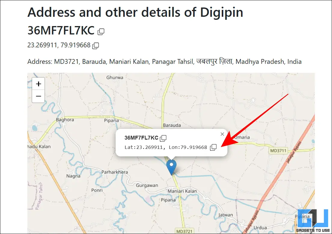
1. Head over to mydigipin.com and scroll down to the Decode DIGIPIN section.
2. Paste your DIGIPIN in the text box and click on Decode DIGIPIN.

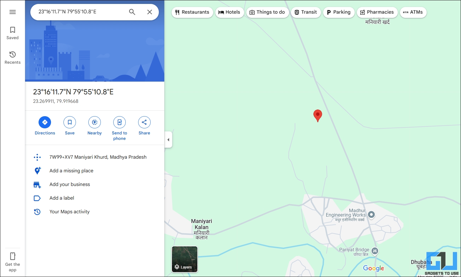
3. The website will show you the exact latitude and longitude of your DIGIPIN. Copy these coordinates and paste them into Google Maps.
How to Know Your DIGIPIN
You can obtain a DIGIPIN for any location in India using the official India Post website by following these steps:
1. Open the DIGIPIN portal by going to dac.indiapost.gov.in/mydigipin.
2. Adjust the map and navigate to the location for which you want to generate the DIGIPIN.
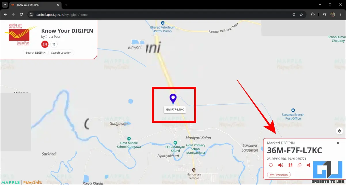
3. Precisely click on the location. The portal will instantly show the DIGIPIN for that selected point.
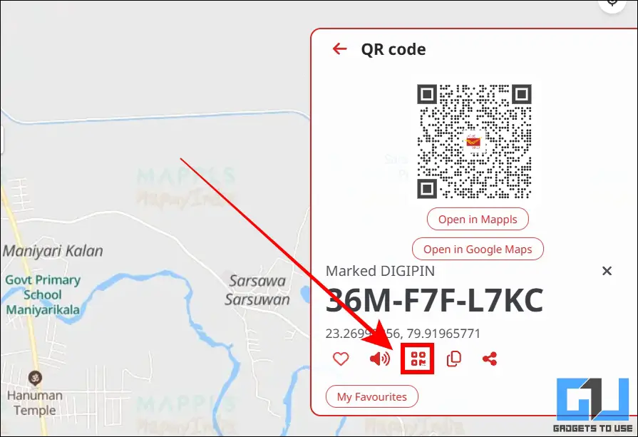
4. You can also create a QR code for this DIGIPIN by using the QR option.
Why Use DIGIPIN?
- DIGIPIN offers pinpoint accuracy for any location on the map using as few characters as possible.
- The system is developed indigenously in India by IIT Hyderabad, India Post, and the India Space Research Organisation (ISRO).
- DIGIPIN also covers newly developed areas in India, including those that do not have a proper PIN code.
- It’s an open-source technology that can be implemented in any existing navigation system. It can be adopted by shipping companies to make it easier to navigate complex addresses.
- As DIGIPIN is recognized by the Government of India, you can use it to mention your location for services related to address identification.
FAQs
Q. How is DIGIPIN different from a regular address?
A regular address uses street names, landmarks, and other parameters, which make it very long. DIGIPIN uses a unique 10-digit alphanumeric code for each location, which makes it easy to identify and locate a place on the map. It also avoids confusion between two locations with similar names.
Q. How accurate is DIGIPIN?
DIGIPIN divides the map of India into a grid of 4 x 4 meter squares, and each square is assigned a unique code. This makes it highly accurate, especially for locating addresses for deliveries. It can also be used to locate a place in emergency situations like floods, forest fires, etc.
Q. Does each flat get a different DIGIPIN in a building?
If a building has multiple rooms and flats in the same location, they will share the same DIGIPIN. In such situations, it’s ideal to mention the room number for doorstep accuracy, followed by the DIGIPIN to locate the building.
Q. Does DIGIPIN store any personal data?
DIGIPIN only provides a navigation service to locate a place on the map and does not store any personal information.
Q. Does DIGIPIN work offline?
Once you generate a DIGIPIN, you can use it to navigate offline without internet. However, you will require a smartphone to decode the DIGIPIN into a normal address.
Wrapping Up
DIGIPIN is an excellent initiative by the Government of India to simplify addresses and help navigate a specific location using a 10-digit alphanumeric code. Since it’s an open-source technology, transport businesses and other entities can implement it for free to simplify complex addresses. DIGIPIN is expected to become a mainstream method of location sharing over the next few years.
You may also like to read:
- How to Put Exact Pin Location of Google Maps in Uber, Rapido and OLA Cabs
- How To Save Your Map Location History From Google To Your Phone
- How to Set Depart and Arrive Time in Google Maps Route
- 5 Ways to Share Live Location Using Google Maps and Other Apps
You can also follow us for instant tech news at Google News or for tips and tricks, smartphones & gadgets reviews, join the GadgetsToUse Telegram Group, or subscribe to the GadgetsToUse Youtube Channel for the latest review videos.